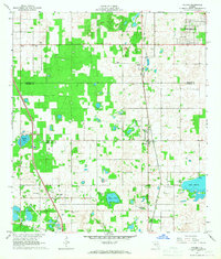
1966 Map of Oxford
USGS Topo · Published 1968About this map
The community of Oxford and the historic settlement of Royal anchor this mid-1960s survey of the Central Florida interior. The landscape is a distinct mix of agricultural clearing and native vegetation, characterized by prominent features like Long Hammock and several small water bodies including Nichols Pond and Gator Pond. The Seaboard Coast Line railroad runs vertically through the center of the sheet, serving as a primary transit artery for the region during this era.
Find a feature on this map
27 named features on this map. Tap any name to fly to it.
Don’t see what you’re looking for? This feature index may not catch every label — zoom into the map to look around manually.
Map Details
Editions of this 1966 Oxford Map
This is the sole edition of this map. No revisions or reprints were ever made.
Other maps of this area

1893 · Panasoffkee
USGS Topo · 1:62,500

1895 · Panasoffkee
USGS Topo · 1:62,500

1895 · Ocala
USGS Topo · 1:62,500

1954 · Gainesville
USGS Topo · 1:250,000

1954 · Daytona Beach
USGS Topo · 1:250,000

1955 · Plant City
USGS Topo · 1:250,000

1955 · Orlando
USGS Topo · 1:250,000

1957 · Orlando
USGS Topo · 1:250,000

1958 · Orlando
USGS Topo · 1:250,000

1958 · Daytona Beach
USGS Topo · 1:250,000