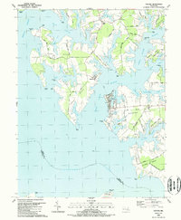
1988 Map of Oxford
USGS Topo · Published 1988About this map
Tred Avon River and the Choptank River define this deeply indented Chesapeake Bay landscape, where water transport once dictated the pace of life. The settlement of Oxford sits at the heart of the map, showing a dense grid of streets and Town Creek docks, while the ferry connection to Bellevue across the water highlights the historical reliance on maritime transit. Inland, the transition from rail to road is evident along the Old Railroad Grade on Oxford Neck, marking the path of the former railway that once served this peninsula.
Find a feature on this map
68 named features on this map. Tap any name to fly to it.
Don’t see what you’re looking for? This feature index may not catch every label — zoom into the map to look around manually.
Map Details
Editions of this 1988 Oxford Map
This is the sole edition of this map. No revisions or reprints were ever made.
Other maps of this area

1892 · Annapolis
USGS Topo · 1:62,500

1893 · Sharps Island
USGS Topo · 1:62,500

1898 · Choptank
USGS Topo · 1:125,000

1904 · St. Michaels
USGS Topo · 1:62,500

1904 · Annapolis
USGS Topo · 1:62,500

1904 · Sharps Island
USGS Topo · 1:62,500

1904 · Oxford
USGS Topo · 1:62,500

1908 · Choptank
USGS Topo · 1:125,000

1942 · Tilghman
USGS Topo · 1:31,680

1942 · Oxford
USGS Topo · 1:31,680