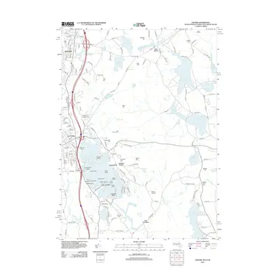
2012 Map of Oxford
USGS Topo · Published 2012About this map
Lake Chaubunagungamaug dominates the southern landscape, its complex shoreline defined by points and islands such as Point Breeze, Treasure Island, and Strip Island. The surrounding residential development is marked by established communities like Wawela Park, Lakeview Heights, and Colonial Park, which cluster near the water. Further north, the town of Oxford and East Village sit near the headwaters of Mill Brook, reflecting the region's dense mix of residential neighborhoods and industrial history. Numerous family-named cemeteries, including Lakeside Cem and Bates Cem, are scattered throughout the hills, providing valuable data for genealogists and local historians. The eastern portion of the map transitions into the wooded expanse of the Douglas State Frst, where the terrain rises toward Mount Daniels and Wadkin Hill. This 2012 survey illustrates the modern configuration of transportation routes like the Central Tpke and Sutton Rd as they navigate the area's many ponds and reservoirs.
Find a feature on this map
116 named features on this map. Tap any name to fly to it.
Don’t see what you’re looking for? This feature index may not catch every label — zoom into the map to look around manually.
Map Details
Editions of this 2012 Oxford Map
This is the sole edition of this map. No revisions or reprints were ever made.
Other maps of this area

1886 · Blackstone
USGS Topo · 1:62,500

1889 · Blackstone
USGS Topo · 1:62,500

1889 · Webster
USGS Topo · 1:62,500

1889 · Putnam
USGS Topo · 1:62,500

1889 · Burrillville
USGS Topo · 1:62,500

1892 · Webster
USGS Topo · 1:62,500

1893 · Putnam
USGS Topo · 1:62,500

1893 · Blackstone
USGS Topo · 1:62,500

1894 · Burrillville
USGS Topo · 1:62,500

1900 · Blackstone
USGS Topo · 1:62,500