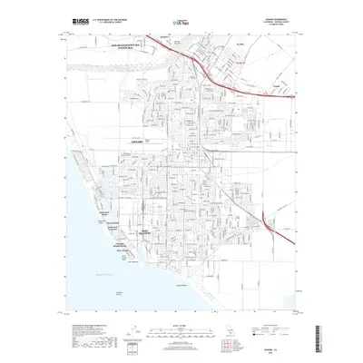
2018 Map of Oxnard
USGS Topo · Published 2018About this map
Oxnard and the industrial coastline of Port Hueneme define this coastal landscape, situated along the southern banks of the Santa Clara River. The map details a densely developed grid where agricultural origins meet modern urbanization, particularly evident near El Rio and Nyland. Genealogists and local historians can locate established burial sites like the Santa Clara Cem and Masonic Cem, or trace the development of educational institutions like Oxnard College. Along the shore, the map documents a series of distinct seaside neighborhoods including Hollywood Beach, Hollywood by the Sea, and Silver Strand, showing their relationship to the Pacific and the deep-water features of Hueneme Canyon. Inland, the Harmon Barranca provides a natural counterpoint to the busy thoroughfares of Ventura Blvd and Oxnard Blvd.
Find a feature on this map
227 named features on this map. Tap any name to fly to it.
Don’t see what you’re looking for? This feature index may not catch every label — zoom into the map to look around manually.
Map Details
Editions of this 2018 Oxnard Map
This is the sole edition of this map. No revisions or reprints were ever made.
Other maps of this area

1903 · Santa Paula
USGS Topo · 1:62,500

1904 · Ventura
USGS Topo · 1:62,500

1904 · Hueneme
USGS Topo · 1:62,500

1941 · Ventura
USGS Topo · 1:62,500

1942 · Santa Paula
USGS Topo · 1:62,500

1942 · Hueneme
USGS Topo · 1:62,500

1943 · Hueneme
USGS Topo · 1:62,500

1947 · Santa Paula
USGS Topo · 1:62,500

1949 · Los Angeles
USGS Topo · 1:250,000

1949 · Oxnard
USGS Topo · 1:24,000