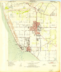
1951 Map of Oxnard
USGS Topo · Published 1951About this map
Coastal Ventura County is anchored by the growing urban center of Oxnard and the industrial activity at Port Hueneme. This mid-century survey reveals a landscape in transition, where established agricultural boundaries like the Santa Clara Del Norte and Rio de Santa Clara meet the expanding military and maritime infrastructure of the Naval Reservation. Along the Pacific Ocean, coastal settlements such as Hollywood Beach, Hollywood by the Sea, and Silver Strand line the dunes of Mandalay Beach and McGrath Beach.
Find a feature on this map
59 named features on this map. Tap any name to fly to it.
Don’t see what you’re looking for? This feature index may not catch every label — zoom into the map to look around manually.
Map Details
Editions of this 1951 Oxnard Map
This is the sole edition of this map. No revisions or reprints were ever made.
Other maps of this area

1903 · Santa Paula
USGS Topo · 1:62,500

1904 · Ventura
USGS Topo · 1:62,500

1904 · Hueneme
USGS Topo · 1:62,500

1941 · Ventura
USGS Topo · 1:62,500

1942 · Santa Paula
USGS Topo · 1:62,500

1942 · Hueneme
USGS Topo · 1:62,500

1943 · Hueneme
USGS Topo · 1:62,500

1947 · Santa Paula
USGS Topo · 1:62,500

1949 · Los Angeles
USGS Topo · 1:250,000

1949 · Oxnard
USGS Topo · 1:24,000