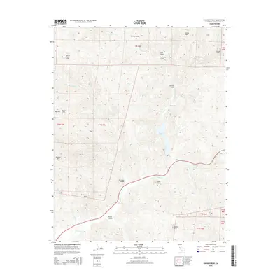
2015 Map of Pacheco Peak
USGS Topo · Published 2015About this map
Pacheco Peak rises as the dominant landmark of this Diablo Range landscape in Santa Clara County, presiding over a complex network of canyons and ridges. The terrain is defined by the convergence of several major creek forks, including the N Fork Pacheco Cr, E Fork Pacheco Cr, and S Fork Pacheco Cr, which feed into the central Pacheco Lake. The rugged geography includes notable named heights such as Burra Burra Peak, Gulnac Peak, and Elephant Head, creating a dramatic series of elevations and depressions like Hurricane Canyon and Harper Canyon. California State Route 152 cuts through the southern portion of the map, providing a modern passage through this historically significant corridor that connects the Santa Clara Valley to the Central Valley. Smaller features like Lovers Leap and Chimney Rock highlight the specific geological character that has drawn surveyors and travelers to this pass for generations.
Find a feature on this map
35 named features on this map. Tap any name to fly to it.
Don’t see what you’re looking for? This feature index may not catch every label — zoom into the map to look around manually.
Map Details
Editions of this 2015 Pacheco Peak Map
This is the sole edition of this map. No revisions or reprints were ever made.
Other maps of this area

1919 · Hollister
USGS Topo · 1:48,000

1920 · Pacheco Pass
USGS Topo · 1:62,500

1921 · Gilroy Hot Springs
USGS Topo · 1:62,500

1921 · Hollister
USGS Topo · 1:62,500

1922 · Quien Sabe
USGS Topo · 1:62,500

1923 · Hollister
USGS Topo · 1:62,500

1939 · Gilroy Hot Springs
USGS Topo · 1:62,500

1940 · Gilroy Hot Springs
USGS Topo · 1:62,500

1940 · Hollister
USGS Topo · 1:62,500

1940 · Pacheco Pass
USGS Topo · 1:62,500