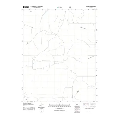
2011 Map of Packers Gap
USGS Topo · Published 2011About this map
Packers Gap serves as a prominent geographic waypoint in this corner of Otero County, where the high plains meet a complex network of canyons and arroyos. The landscape is defined by the drainage patterns of the West Branch Crooked Arroyo and East Branch Crooked Arroyo, which carve through the terrain toward the Shale Hills. This 2011 survey reveals a sparse rangeland infrastructure characterized by isolated landmarks such as Honeys Windmill and the Browning and Reese Number 2 Dam.
Find a feature on this map
16 named features on this map. Tap any name to fly to it.
Don’t see what you’re looking for? This feature index may not catch every label — zoom into the map to look around manually.
Map Details
Editions of this 2011 Packers Gap Map
This is the sole edition of this map. No revisions or reprints were ever made.
Other maps of this area

1891 · Timpas
USGS Topo · 1:125,000

1894 · Timpas
USGS Topo · 1:125,000

1955 · La Junta
USGS Topo · 1:250,000

1958 · La Junta
USGS Topo · 1:250,000

1965 · La Junta SW
USGS Topo · 1:24,000

1966 · La Junta SE
USGS Topo · 1:24,000

1968 · La Junta
USGS Topo · 1:250,000

1972 · Packers Gap
USGS Topo · 1:24,000
1972 · Stage Canyon
USGS Topo · 1:24,000
1972 · Beaty Canyon
USGS Topo · 1:24,000