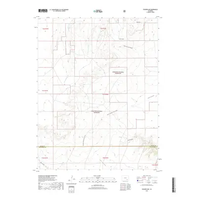
2019 Map of Packers Gap
USGS Topo · Published 2019About this map
The Comanche National Grassland dominates this section of southeastern Colorado, where the high plains break into a complex system of drainages and mesas. This landscape is defined by the historic route of the Barlow-Sanderson Wagon Road, which cuts diagonally across the terrain, serving as a reminder of early stagecoach and freighting corridors through the Southwest. The topography is deeply etched by a network of seasonal watercourses and canyons, including Minnie Canyon, Iron Canyon, and the headwaters of Bent Canyon. The terrain rises toward the Shale Hills in the north, where the landmark Packers Gap provides a natural passage through the elevated ridges. This area, straddling the line between Otero and Las Animas counties, remains largely defined by its open range and the intricate bifurcations of the W Br Crooked Arroyo and E-Br Crooked Arroyo.
Find a feature on this map
12 named features on this map. Tap any name to fly to it.
Don’t see what you’re looking for? This feature index may not catch every label — zoom into the map to look around manually.
Map Details
Editions of this 2019 Packers Gap Map
This is the sole edition of this map. No revisions or reprints were ever made.
Other maps of this area

1891 · Timpas
USGS Topo · 1:125,000

1894 · Timpas
USGS Topo · 1:125,000

1955 · La Junta
USGS Topo · 1:250,000

1958 · La Junta
USGS Topo · 1:250,000

1965 · La Junta SW
USGS Topo · 1:24,000

1966 · La Junta SE
USGS Topo · 1:24,000

1968 · La Junta
USGS Topo · 1:250,000

1972 · Packers Gap
USGS Topo · 1:24,000
1972 · Stage Canyon
USGS Topo · 1:24,000
1972 · Beaty Canyon
USGS Topo · 1:24,000