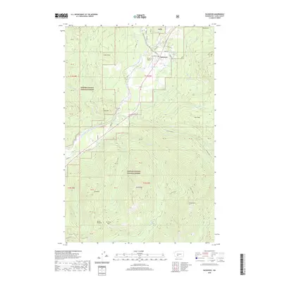
2020 Map of Packwood
USGS Topo · Published 2020About this map
Packwood serves as a central hub in this high-altitude landscape of Lewis County, where the valley of the Cowlitz River carves through the protected wilderness of the Gifford Pinchot National Forest. This 2020 record details a complex drainage network feeding into the river, including Willame Creek and Johnson Creek. The topography is defined by prominent peaks and ridges such as Pompey Peak and Smith Ridge, alongside massive geological features like Cougar Rocks and the distinctive Goat Dike. Human infrastructure is concentrated near the valley floor, evidenced by Packwood Airport and the engineered Tail Race near the river's bend. To the north, the label Big Bottom identifies the floodplain, while higher elevations reveal remote alpine features like Snyder Lake and Hager Lake. The map provides a clear look at the intersection of forest management boundaries and the local road network including Skate Creek Road S.
Find a feature on this map
66 named features on this map. Tap any name to fly to it.
Don’t see what you’re looking for? This feature index may not catch every label — zoom into the map to look around manually.
Map Details
Editions of this 2020 Packwood Map
This is the sole edition of this map. No revisions or reprints were ever made.
Other maps of this area

1924 · Mt Rainier
USGS Topo · 1:96,000

1926 · Steamboat Mtn
USGS Topo · 1:125,000

1928 · Mt Rainier
USGS Topo · 1:125,000

1931 · Steamboat Mtn
USGS Topo · 1:125,000

1950 · Yakima
USGS Topo · 1:250,000

1958 · Yakima
USGS Topo · 1:250,000

1961 · Yakima
USGS Topo · 1:250,000

1962 · Randle
USGS Topo · 1:62,500

1962 · Packwood
USGS Topo · 1:62,500
1965 · Tower Rock
USGS Topo · 1:24,000