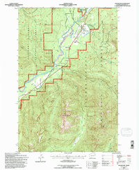
1994 Map of Packwood
USGS Topo · Published 1996About this map
Packwood serves as the primary gateway to the high elevations of the Gifford Pinchot National Forest in this mid-1990s revision. The settlement sits within the Big Bottom valley, where the Cowlitz River meanders through a landscape defined by sharp topographical contrasts. Local infrastructure is concentrated along the river floor, featuring a prominent Landing Strip and a network of access routes like Johnson Cr Rd and Baker Road. The surrounding heights are marked by named geological features such as Cougar Rocks and Skye Mtn, alongside remote water bodies like Hager Lake and Snyder Lake. This map represents the forest's dual nature as both a timber resource, indicated by several Borrow Pit locations, and a wilderness area containing the quiet Burton Meadows and the high Dry Creek Pass.
Find a feature on this map
37 named features on this map. Tap any name to fly to it.
Don’t see what you’re looking for? This feature index may not catch every label — zoom into the map to look around manually.
Map Details
Editions of this 1994 Packwood Map
This is the sole edition of this map. No revisions or reprints were ever made.
Other maps of this area

1924 · Mt Rainier
USGS Topo · 1:96,000

1926 · Steamboat Mtn
USGS Topo · 1:125,000

1928 · Mt Rainier
USGS Topo · 1:125,000

1931 · Steamboat Mtn
USGS Topo · 1:125,000

1950 · Yakima
USGS Topo · 1:250,000

1958 · Yakima
USGS Topo · 1:250,000

1961 · Yakima
USGS Topo · 1:250,000

1962 · Randle
USGS Topo · 1:62,500

1962 · Packwood
USGS Topo · 1:62,500
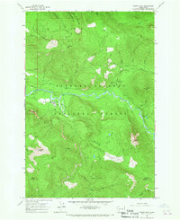
1965 · Tower Rock
USGS Topo · 1:24,000