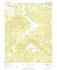
1951 Map of Page Ranch
USGS Topo · Published 1951About this map
Old Irontown (Historic Site) and its surrounding Ruins anchor the northern landscape of this map, reflecting the mid-19th-century efforts to establish an iron industry in southern Utah. This industrial activity is further evidenced by the concentrated mining infrastructure near Iron Mountain, including the Columbia Steel Mine and the Blowout Pit connected by the Union Pacific railroad. The map highlights a remote ranching economy, with properties such as Page Ranch, Grants Ranch, and Upper Grants Ranch scattered along the drainages.
Find a feature on this map
37 named features on this map. Tap any name to fly to it.
Don’t see what you’re looking for? This feature index may not catch every label — zoom into the map to look around manually.
Map Details
Editions of this 1951 Page Ranch Map
2 editions found

Other maps of this area

1885 · St. George
USGS Topo · 1:250,000

1891 · St. George
USGS Topo · 1:250,000

1950 · Iron Mountain
USGS Topo · 1:62,500

1950 · Stoddard Mtn
USGS Topo · 1:24,000

1950 · Silver Peak
USGS Topo · 1:24,000

1950 · Desert Mound
USGS Topo · 1:24,000

1950 · Page Ranch
USGS Topo · 1:24,000

1951 · Silver Peak
USGS Topo · 1:24,000
1951 · Desert Mound
USGS Topo · 1:24,000

1951 · Stoddard Mtn
USGS Topo · 1:24,000