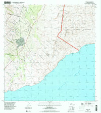
1995 Map of Pahala
USGS Topo · Published 2000About this map
Pahala serves as the primary settlement on this section of the island, where the residential grid meets the coastal slopes of the Ka'u District. The landscape is defined by the descent from the high volcanic reaches of Hawaii Volcanoes National Park down to the Pacific Ocean, marked by a series of deep gulches including Ka ala ala Gulch and Hionamoa Gulch. Cultural history is noted through several former plantation settlements now designated as sites, such as Keaiwa Camp and Meyer Camp, providing clues for genealogists looking into the region's labor history. Near the shore, the geology takes a distinct turn with the Lava-Plastered Dunes and Keone'ele'ele Flat, while the Pahala Landing Strip and a local Cemetery anchor the community's infrastructure and heritage.
Find a feature on this map
61 named features on this map. Tap any name to fly to it.
Don’t see what you’re looking for? This feature index may not catch every label — zoom into the map to look around manually.
Map Details
Editions of this 1995 Pahala Map
This is the sole edition of this map. No revisions or reprints were ever made.
Other maps of this area

1921 · Kilauea
USGS Topo · 1:62,500

1923 · Pahala
USGS Topo · 1:62,500

1924 · Kilauea
USGS Topo · 1:62,500

1924 · Honuapo
USGS Topo · 1:62,500

1928 · Mauna Loa
USGS Topo · 1:62,500

1954 · Hawaii South
USGS Topo · 1:250,000

1959 · Hawaii South
USGS Topo · 1:250,000

1961 · Hawaii South
USGS Topo · 1:250,000

1962 · Hawaii South
USGS Topo · 1:250,000
1962 · Naalehu
USGS Topo · 1:24,000