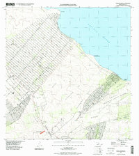
1995 Map of Pahoa North
USGS Topo · Published 2000About this map
The Lava Flow of 1840 cuts a distinct path across this Puna coastline, showing the volcanic history that continues to shape the region. This survey of the late 1990s illustrates the transformation of traditional land divisions into large residential subdivisions, with long arterial roads like Kaloli Drive and Paradise Drive extending toward the Pacific Ocean. Despite the modern grid-style development of the Keaau area, traces of earlier coastal activity remain visible.
Find a feature on this map
42 named features on this map. Tap any name to fly to it.
Don’t see what you’re looking for? This feature index may not catch every label — zoom into the map to look around manually.
Map Details
Editions of this 1995 Pahoa North Map
This is the sole edition of this map. No revisions or reprints were ever made.
Other maps of this area

1917 · Hilo
USGS Topo · 1:62,500

1922 · Puna
USGS Topo · 1:62,500

1924 · Makuu
USGS Topo · 1:62,500

1924 · Puna
USGS Topo · 1:62,500

1924 · Kalapana
USGS Topo · 1:62,500

1932 · Hilo
USGS Topo · 1:62,500

1954 · Hawaii South
USGS Topo · 1:250,000

1954 · Hawaii North
USGS Topo · 1:250,000

1959 · Hawaii South
USGS Topo · 1:250,000

1959 · Hawaii North
USGS Topo · 1:250,000