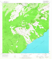
1966 Map of Pahoa South
USGS Topo · Published 1967About this map
Volcanic activity defines the Puna District landscape on the Island of Hawaii during the mid-1960s. The map captures the significant reach of the Lava Flow of 1955, which cuts broad paths through the Kamaili Homesteads and Kauauleau toward the Pacific Ocean. This survey reveals the intersection of agricultural resilience and geological instability, noting the Univ of Hawaii Experimental Station alongside several cinder pits. Settlements like Pahoa and Kaniahiku Village are surrounded by extensive forest reserves, including the Puna Forest Reserve. Along the coast, small coastal sites like Opthikao and Lolia sit near Mackenzie State Park, illustrating how local communities and recreation areas coexist with active rift zones. These features, combined with older paths such as the Lava Flow of 1750, provide a detailed record of the island's shifting topography before later major eruptions.
Find a feature on this map
71 named features on this map. Tap any name to fly to it.
Don’t see what you’re looking for? This feature index may not catch every label — zoom into the map to look around manually.
Map Details
Editions of this 1966 Pahoa South Map
This is the sole edition of this map. No revisions or reprints were ever made.
Other maps of this area

1917 · Hilo
USGS Topo · 1:62,500

1922 · Puna
USGS Topo · 1:62,500

1924 · Makuu
USGS Topo · 1:62,500

1924 · Puna
USGS Topo · 1:62,500

1924 · Kalapana
USGS Topo · 1:62,500

1932 · Hilo
USGS Topo · 1:62,500

1954 · Hawaii South
USGS Topo · 1:250,000

1954 · Hawaii North
USGS Topo · 1:250,000

1959 · Hawaii South
USGS Topo · 1:250,000

1959 · Hawaii North
USGS Topo · 1:250,000