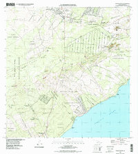
1994 Map of Pahoa South
USGS Topo · Published 1998About this map
Pahoa serves as the inland anchor for this coastal survey of the Puna District, where the land is defined by active volcanic history. The topography is dominated by the East Rift Zone and the expansive path of the Lava Flow of 1955, which cuts a wide swath toward the Pacific Ocean. Settlement patterns are distinctly organized into traditional lots such as Kamaili Homesteads, Kikala Keokea Homesteads, and Opihikao Homesteads, reflecting the local agricultural and residential history of the Big Island. Along the rugged southeastern shoreline, small communities like Opihikao, Lolia, and Kehena are connected by coastal routes. Further inland, the University of Hawaii Experimental Station sits near several cinder cones and craters, highlighting the region's importance for geological and botanical research within the Puna Forest Reserve.
Find a feature on this map
73 named features on this map. Tap any name to fly to it.
Don’t see what you’re looking for? This feature index may not catch every label — zoom into the map to look around manually.
Map Details
Editions of this 1994 Pahoa South Map
This is the sole edition of this map. No revisions or reprints were ever made.
Other maps of this area

1917 · Hilo
USGS Topo · 1:62,500

1922 · Puna
USGS Topo · 1:62,500

1924 · Makuu
USGS Topo · 1:62,500

1924 · Puna
USGS Topo · 1:62,500

1924 · Kalapana
USGS Topo · 1:62,500

1932 · Hilo
USGS Topo · 1:62,500

1954 · Hawaii South
USGS Topo · 1:250,000

1954 · Hawaii North
USGS Topo · 1:250,000

1959 · Hawaii South
USGS Topo · 1:250,000

1959 · Hawaii North
USGS Topo · 1:250,000