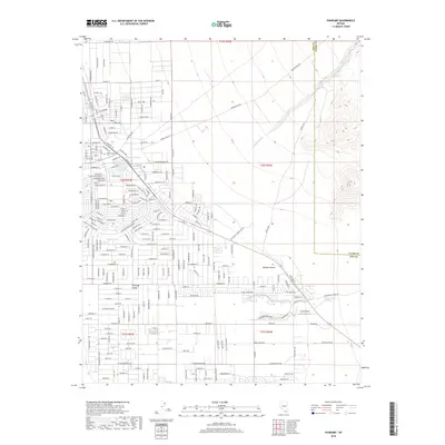
2018 Map of Pahrump
USGS Topo · Published 2018About this map
Pahrump Valley serves as a critical desert basin along the Nye and Clark County line, where the landscape is defined by its vital water sources. The importance of groundwater in this arid Mojave Desert environment is evidenced by the concentration of natural landmarks like Pahrump Springs, Ivanpah Springs, and Stump Springs. These sites have historically supported the area's growth from ranching roots into a modern desert community. Cultural and infrastructure development is visible through the presence of the Chief Tecopa Cem and Caas Airport. The local economy and transportation network are further illustrated by specialized thoroughfares such as Winery Rd and Wulfenstein Gravel Pit Rd, while the ephemeral Wheeler Wash drains the sloping terrain to the northeast, marking the intersection of natural hydrology and human settlement.
Find a feature on this map
42 named features on this map. Tap any name to fly to it.
Don’t see what you’re looking for? This feature index may not catch every label — zoom into the map to look around manually.
Map Details
Editions of this 2018 Pahrump Map
This is the sole edition of this map. No revisions or reprints were ever made.
Other maps of this area

1907 · Las Vegas
USGS Topo · 1:250,000

1908 · Furnace Creek
USGS Topo · 1:250,000

1908 · Las Vegas
USGS Topo · 1:250,000

1910 · Furnace Creek
USGS Topo · 1:250,000

1948 · Death Valley
USGS Topo · 1:250,000

1954 · Las Vegas
USGS Topo · 1:250,000

1954 · Death Valley
USGS Topo · 1:250,000

1956 · Death Valley
USGS Topo · 1:250,000

1957 · Las Vegas
USGS Topo · 1:250,000

1957 · Death Valley
USGS Topo · 1:250,000