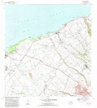
1983 Map of Paia
USGS Topo · Published 1983About this map
The agricultural and coastal landscape of northern Maui is defined here by the infrastructure of the sugar industry and the growing transit hub at Kahului Airport. Inland from the Pacific Ocean, the land is a complex network of ditches, siphons, and aqueducts feeding the fields surrounding Puunene, where the Sugar Mill and Spanish B Village stand as markers of the island's plantation history. Transportation patterns are in transition, visible in the Old Railroad Grade that winds toward Paia and Kuau, contrasted with the rising importance of the Hana Highway.
Find a feature on this map
49 named features on this map. Tap any name to fly to it.
Don’t see what you’re looking for? This feature index may not catch every label — zoom into the map to look around manually.
Map Details
Editions of this 1983 Paia Map
This is the sole edition of this map. No revisions or reprints were ever made.
Other maps of this area

1954 · Maui
USGS Topo · 1:250,000

1954 · Maalaea
USGS Topo · 1:24,000

1954 · Paia
USGS Topo · 1:24,000

1954 · Puu O Kali
USGS Topo · 1:24,000

1955 · Wailuku
USGS Topo · 1:24,000

1955 · Kahakuloa
USGS Topo · 1:24,000

1957 · Kilohana
USGS Topo · 1:24,000

1957 · Haiku
USGS Topo · 1:24,000

1966 · Maui
USGS Topo · 1:250,000

1974 · Maui
USGS Topo · 1:250,000