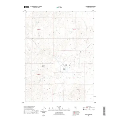
2018 Map of Paiute Meadows
USGS Topo · Published 2018About this map
Lassens Grave May 59 stands as a solitary historical marker in this remote pocket of the Black Rock Range, anchoring the landscape to the mid-19th-century pioneer era. The terrain is defined by a critical network of water sources essential for survival in the high desert, including Johnstone Springs, Onemile Spring, and the clustered Cherry Springs. These perennial points supported the establishment of Paiute Meadows, where the Paiute Meadows Airport provides a modern, though isolated, connection to the wider region. To the southeast, Elephant Mtn rises above the drainage of Paiute Cr, illustrating the stark elevation changes typical of Humboldt County. The map traces early transportation and land management corridors like Leonard Creek Rd and Farm Rd, which weave between these scattered springs and the rocky outcrops of the range.
Find a feature on this map
20 named features on this map. Tap any name to fly to it.
Don’t see what you’re looking for? This feature index may not catch every label — zoom into the map to look around manually.
Map Details
Editions of this 2018 Paiute Meadows Map
This is the sole edition of this map. No revisions or reprints were ever made.
Other maps of this area

1886 · Disaster
USGS Topo · 1:250,000

1889 · Long Valley
USGS Topo · 1:250,000

1893 · Disaster
USGS Topo · 1:250,000

1954 · Vya
USGS Topo · 1:250,000

1958 · Vya
USGS Topo · 1:250,000

1962 · Vya
USGS Topo · 1:250,000

1972 · Pinto Mountain
USGS Topo · 1:24,000

1972 · Burnt Springs
USGS Topo · 1:24,000

1972 · Big Mountain
USGS Topo · 1:24,000
1972 · Red Mountain
USGS Topo · 1:24,000