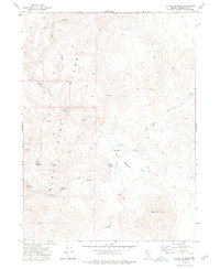
1972 Map of Paiute Meadows
USGS Topo · Published 1977About this map
Paiute Meadows Ranch sits at the heart of this high-desert landscape, serving as a primary point of human activity within the larger Paiute Meadows basin. The area is dominated by the steep rises of the Black Rock Range to the west and the prominent peak of Elephant Mtn to the south. This 1970s survey illustrates a rugged ranching and grazing environment where water sources are the most critical landmarks.
Find a feature on this map
19 named features on this map. Tap any name to fly to it.
Don’t see what you’re looking for? This feature index may not catch every label — zoom into the map to look around manually.
Map Details
Editions of this 1972 Paiute Meadows Map
This is the sole edition of this map. No revisions or reprints were ever made.
Other maps of this area

1886 · Disaster
USGS Topo · 1:250,000

1889 · Long Valley
USGS Topo · 1:250,000

1893 · Disaster
USGS Topo · 1:250,000

1954 · Vya
USGS Topo · 1:250,000

1958 · Vya
USGS Topo · 1:250,000

1962 · Vya
USGS Topo · 1:250,000

1972 · Pinto Mountain
USGS Topo · 1:24,000

1972 · Burnt Springs
USGS Topo · 1:24,000

1972 · Big Mountain
USGS Topo · 1:24,000
1972 · Red Mountain
USGS Topo · 1:24,000