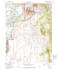
1970 Map of Palermo
USGS Topo · Published 1973About this map
Dredge tailings dominate the landscape north of Palermo, evidence of the heavy industrial gold mining that shaped this section of Butte County. This 1970 field-checked survey illustrates the transition from the river-bottom mining areas to the developing residential and educational centers of South Oroville and Vista Robles. Transport infrastructure is central to the area's layout, with the Western Pacific Railroad and Southern Pacific lines running parallel through the valley. Educational landmarks like Las Plumas High Sch and Oakdale Heights Sch appear alongside established sites like the Oroville Cem and Memorial Park Cemetery. The map also captures the managed water systems of the region, including the Palermo Substation and various irrigation works such as the Henderson Ditch and Wyman Ditch.
Find a feature on this map
39 named features on this map. Tap any name to fly to it.
Don’t see what you’re looking for? This feature index may not catch every label — zoom into the map to look around manually.
Map Details
Editions of this 1970 Palermo Map
3 editions found
Other maps of this area

1888 · Marysville
USGS Topo · 1:125,000

1888 · Smartsville
USGS Topo · 1:125,000

1888 · Bidwell Bar
USGS Topo · 1:125,000

1891 · Bidwell Bar
USGS Topo · 1:125,000

1891 · Chico
USGS Topo · 1:125,000

1891 · Marysville
USGS Topo · 1:125,000

1891 · Smartsville
USGS Topo · 1:125,000

1892 · Smartsville
USGS Topo · 1:125,000

1893 · Chico
USGS Topo · 1:125,000

1893 · Bidwell Bar
USGS Topo · 1:125,000