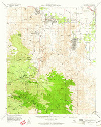
1959 Map of Palm Desert
USGS Topo · Published 1961About this map
Palm Desert and the surrounding Coachella Valley are shown here during a transformative era of mid-century development. The map documents established communities like Rancho Mirage, Indian Wells, and La Quinta alongside isolated outposts such as Shumway Ranch and the Indian Village site. To the south, the landscape rises sharply into the Santa Rosa Mountains, where the San Bernardino National Forest and the Santa Rosa Indian Reservation preserve a more primitive character. Industrial and agricultural infrastructure is evident in the Coachella Canal and scattered resource extraction sites, including the Asbestos Mine, Dolomite Mine, and Garnet Queen Mine. Transportation is anchored by the Southern Pacific railroad in the north and the winding Pines to Palms Highway that climbs toward Ribbonwood.
Find a feature on this map
84 named features on this map. Tap any name to fly to it.
Don’t see what you’re looking for? This feature index may not catch every label — zoom into the map to look around manually.
Map Details
Editions of this 1959 Palm Desert Map
4 editions found
Other maps of this area

1901 · Southern California Sheet No. 1
USGS Topo · 1:250,000

1901 · San Jacinto
USGS Topo · 1:125,000

1903 · Ramona
USGS Topo · 1:125,000

1904 · Indio
USGS Topo · 1:125,000

1904 · Southern California Sheet No. 2
USGS Topo · 1:250,000

1904 · Southern California Sheet No. 1
USGS Topo · 1:250,000

1931 · Vallecito
USGS Topo · 1:125,000

1939 · Warner Springs
USGS Topo · 1:62,500

1940 · Palm Springs
USGS Topo · 1:62,500

1940 · Hemet Reservoir
USGS Topo · 1:62,500