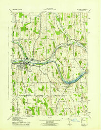
1943 Map of Palmyra
USGS Topo · Published 1943About this map
Hill Cumorah and its landmark Angel Moroni Monument dominate the southern landscape of this mid-century survey, marking a site of immense significance for the Church of Jesus Christ of Latter-day Saints. The map captures the industrial and agricultural rhythm of Wayne County during the war years, with the State Barge Canal cutting through the center of Palmyra and broadening into The Wide Waters near Port Gibson.
Find a feature on this map
74 named features on this map. Tap any name to fly to it.
Don’t see what you’re looking for? This feature index may not catch every label — zoom into the map to look around manually.
Map Details
Editions of this 1943 Palmyra Map
This is the sole edition of this map. No revisions or reprints were ever made.
Other maps of this area

1899 · Palmyra
USGS Topo · 1:62,500

1900 · Macedon
USGS Topo · 1:62,500

1900 · Canandaigua
USGS Topo · 1:62,500

1902 · Phelps
USGS Topo · 1:62,500

1902 · Palmyra
USGS Topo · 1:62,500

1903 · Canandaigua
USGS Topo · 1:62,500

1942 · Ontario
USGS Topo · 1:31,680

1942 · Canandaigua
USGS Topo · 1:31,680

1943 · Phelps
USGS Topo · 1:31,680

1943 · Williamson
USGS Topo · 1:31,680