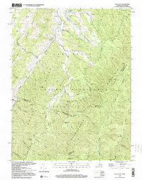
1999 Map of Palo Alto
USGS Topo · Published 2000About this map
Palo Alto and the surrounding borderlands of Virginia and West Virginia are defined by the steep, parallel ridges of the central Appalachians. The South Fork Potomac River cuts through the northwest corner of the quadrangle, where early community life centered around local congregations like Crummett Ch and Wilfong Ch. Most of the landscape is dominated by the George Washington National Forest, covering prominent landforms including Hoover Mountain and Shenandoah Mountain. This topography dictated a settlement pattern confined to narrow hollows and valleys, such as Huffman Hollow and Varner Hollow, where small family holdings and cemeteries likely once lined the drainages. Numerous springs and runs, including Rock Lick Spring and Stony Run, provide the water sources for this high-elevation terrain, while several small dams like Dam No 18 indicate localized water management within the forest.
Find a feature on this map
57 named features on this map. Tap any name to fly to it.
Don’t see what you’re looking for? This feature index may not catch every label — zoom into the map to look around manually.
Map Details
Editions of this 1999 Palo Alto Map
This is the sole edition of this map. No revisions or reprints were ever made.
Other maps of this area

1892 · Franklin
USGS Topo · 1:125,000

1894 · Staunton
USGS Topo · 1:125,000

1896 · Franklin
USGS Topo · 1:125,000

1922 · Fort Seybert
USGS Topo · 1:48,000

1922 · Circleville
USGS Topo · 1:62,500

1924 · Circleville
USGS Topo · 1:48,000

1924 · Mc Dowell
USGS Topo · 1:62,500

1924 · Fort Seybert
USGS Topo · 1:62,500

1944 · Parnassus
USGS Topo · 1:62,500

1944 · Mc Dowell
USGS Topo · 1:62,500