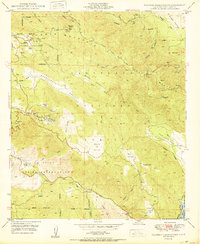
1950 Map of Palomar Observatory
USGS Topo · Published 1950About this map
Palomar Observatory dominates the high elevations of Palomar Mountain, providing a detailed look at the scientific infrastructure of the mid-century, including the famed Hale Telescope (200-inch). The landscape transitions from these astronomical heights down into the La Jolla Indian Reservation and the broad pastoral reaches of Mendenhall Valley.
Find a feature on this map
48 named features on this map. Tap any name to fly to it.
Don’t see what you’re looking for? This feature index may not catch every label — zoom into the map to look around manually.
Map Details
Editions of this 1950 Palomar Observatory Map
2 editions found
Other maps of this area

1903 · Ramona
USGS Topo · 1:125,000

1904 · Southern California Sheet No. 2
USGS Topo · 1:250,000

1939 · Warner Springs
USGS Topo · 1:62,500

1939 · Santa Ysabel
USGS Topo · 1:62,500

1939 · Palomar Mountain
USGS Topo · 1:62,500

1942 · Ramona
USGS Topo · 1:62,500

1943 · Santa Ysabel
USGS Topo · 1:62,500

1943 · Warner Springs
USGS Topo · 1:62,500

1947 · Ramona
USGS Topo · 1:62,500

1947 · Santa Ana
USGS Topo · 1:250,000