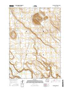
2017 Map of Palomino Buttes
USGS Topo · Published 2017About this map
Palomino Buttes and the dramatic basaltic uplift of the Palomino Rim anchor this high-desert landscape in central Harney County. The area is defined by a sophisticated network of water management features, including the Bunch Grass Reservoir, Palomino Rim Reservoir, and Fay Canyon Reservoir, which support life in this arid basin. This 2017 survey reveals the reliance on local topography for water retention, as seen in the clustered water holes like Obiaque Water Hole and Long Rabbit Water Hole.
Find a feature on this map
29 named features on this map. Tap any name to fly to it.
Don’t see what you’re looking for? This feature index may not catch every label — zoom into the map to look around manually.
Map Details
Editions of this 2017 Palomino Buttes Map
This is the sole edition of this map. No revisions or reprints were ever made.
Other maps of this area

1955 · Burns
USGS Topo · 1:250,000

1958 · Burns
USGS Topo · 1:250,000

1959 · Burns
USGS Topo · 1:250,000

1959 · Dog Mountain
USGS Topo · 1:62,500

1960 · Burns
USGS Topo · 1:62,500

1979 · Moon Reservoir
USGS Topo · 1:24,000

1980 · Iron Mtn. Flat
USGS Topo · 1:24,000

1980 · Stinking Lake
USGS Topo · 1:24,000

1980 · Palomino Buttes
USGS Topo · 1:24,000

1981 · Sage Hen Hill
USGS Topo · 1:24,000