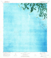
1974 Map of Panther Key
USGS Topo · Published 1976About this map
The Ten Thousand Islands emerge from the shallow coastal waters of Collier County in this orthophotomap, showing the intricate mangrove landscape of the southwest Florida coast. This transitional zone where the Gulf of Mexico meets the land is defined by complex tidal channels including White Horse Key Pass and Dismal Key Pass, which weave around landmarks like Panther Key and Sullivan Key. The eastern portion of the map is protected as part of Everglades National Park, its boundary marked as an indefinite line through the shifting wetlands. Local features such as Camp Lulu Key and Gomez Pt highlight the small-scale human and geographical points of interest within Gullivan Bay before the modern era of intensive development. The map utilizes 1971 aerial photography and 1974 topographic surveys to document this fluid environment.
Find a feature on this map
15 named features on this map. Tap any name to fly to it.
Don’t see what you’re looking for? This feature index may not catch every label — zoom into the map to look around manually.
Map Details
Editions of this 1974 Panther Key Map
This is the sole edition of this map. No revisions or reprints were ever made.
Other maps of this area

1956 · Miami
USGS Topo · 1:250,000

1958 · Miami
USGS Topo · 1:250,000

1972 · Weavers Station
USGS Topo · 1:24,000

1973 · Cape Romano
USGS Topo · 1:24,000

1973 · Marco Island
USGS Topo · 1:24,000
1973 · Royal Palm Hammock
USGS Topo · 1:24,000
1974 · Everglades City
USGS Topo · 1:24,000

1982 · Everglades City
USGS Topo · 1:100,000

1988 · Miami
USGS Topo · 1:250,000
1995 · Marco Island
USGS Topo · 1:24,000