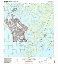
1995 Map of Marco Island
USGS Topo · Published 1999About this map
Marco and its complex network of man-made canals and coastal developments define this mid-1990s portrait of Southwest Florida. The map illustrates the intense residential expansion of the island, including the prominent Marco Beach shoreline and the centralized Barfield Sch. To the north, the finger islands of the Isles of Capri stand out against the waters of Johnson Bay, while the eastern portion of the quadrangle remains largely dominated by the mangroves and tidal channels of the Cape Romano Ten Thousand Islands State Aquatic Preserve. This contrast between the engineered waterfront of the main settlement and the wilder reaches of Horrs Island and Kice Island highlights the era's balance of growth and preservation. Notable infrastructure includes the Toll Bridge connecting the north end of the island and a Landing Strip situated near McIlvane Bay.
Find a feature on this map
57 named features on this map. Tap any name to fly to it.
Don’t see what you’re looking for? This feature index may not catch every label — zoom into the map to look around manually.
Map Details
Editions of this 1995 Marco Island Map
This is the sole edition of this map. No revisions or reprints were ever made.
Other maps of this area

1956 · Miami
USGS Topo · 1:250,000

1956 · West Palm Beach
USGS Topo · 1:250,000

1957 · West Palm Beach
USGS Topo · 1:250,000

1958 · West Palm Beach
USGS Topo · 1:250,000

1958 · Miami
USGS Topo · 1:250,000

1958 · Belle Meade
USGS Topo · 1:24,000

1958 · Naples South
USGS Topo · 1:24,000

1958 · Belle Meade SE
USGS Topo · 1:24,000

1973 · Cape Romano
USGS Topo · 1:24,000

1973 · Marco Island
USGS Topo · 1:24,000