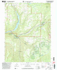
2001 Map of Paonia Reservoir
USGS Topo · Published 2004About this map
Paonia Reservoir and the Paonia State Recreation Area dominate this high-altitude landscape where the North Fork Gunnison River meets the waters of Anthracite Creek and Muddy Creek. The geography reveals a legacy of seasonal resource use and ranching history, evidenced by the Snowshoe Cow Camp, Snowshoe Cabin, and the Hotchkiss Ranch. Notable infrastructure includes the Ruby Stock Driveway and the Elkhorn Ditch, illustrating how the land has been managed for both agriculture and livestock movement. To the east, the dramatic heights of Marcellina Mountain and the Raggeds Wilderness provide a sharp vertical contrast to the broad surfaces of Raven Mesa and Snowshoe Mesa. This 2001 revision by the Forest Service provides a detailed look at public lands management within the Gunnison National Forest at the turn of the century.
Find a feature on this map
48 named features on this map. Tap any name to fly to it.
Don’t see what you’re looking for? This feature index may not catch every label — zoom into the map to look around manually.
Map Details
Editions of this 2001 Paonia Reservoir Map
This is the sole edition of this map. No revisions or reprints were ever made.
Other maps of this area

1888 · Anthracite
USGS Topo · 1:62,500

1889 · Anthracite
USGS Topo · 1:62,500

1893 · Anthracite
USGS Topo · 1:62,500

1894 · Anthracite
USGS Topo · 1:62,500

1938 · Mt. Gunnison
USGS Topo · 1:48,000

1945 · Mount Gunnison
USGS Topo · 1:62,500

1956 · Montrose
USGS Topo · 1:250,000

1957 · Leadville
USGS Topo · 1:250,000

1959 · Leadville
USGS Topo · 1:250,000

1959 · Montrose
USGS Topo · 1:250,000