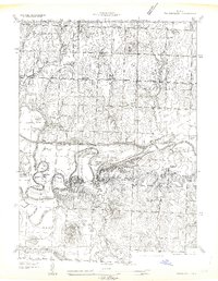
1963 Map of Papinsville
USGS Topo · Published 1963About this map
The Old Harmony Mission Site stands as a significant historical marker in this 1934 survey of Bates County, reflecting early settlement patterns along the Marais des Cygnes River. The landscape is defined by the river's winding path through numerous bends and sloughs, including Camm Bend, Beasley Bend, and the Hirni Slough. This waterway network, coupled with the Marais des Cygnes Drainage Ditch, indicates a region deeply engaged with land reclamation and water management for agriculture. Smaller communities like Papinsville, Rockville, and Prairie City anchor the rural infrastructure, supported by a dense distribution of local institutions such as the Happy Hill Ch, Belvoir Sch, and the German Reformed Ch. Further south, the Pepper Mill and Cresap Ranch illustrate the localized rural economy and land use during the mid-20th century.
Find a feature on this map
60 named features on this map. Tap any name to fly to it.
Don’t see what you’re looking for? This feature index may not catch every label — zoom into the map to look around manually.
Map Details
Editions of this 1963 Papinsville Map
This is the sole edition of this map. No revisions or reprints were ever made.
Other maps of this area

1886 · Nevada
USGS Topo · 1:125,000

1887 · Butler
USGS Topo · 1:125,000

1894 · Butler
USGS Topo · 1:125,000

1894 · Nevada
USGS Topo · 1:125,000

1934 · Papinsville
USGS Topo · 1:24,000

1934 · Rockville
USGS Topo · 1:24,000

1936 · Rich Hill
USGS Topo · 1:24,000

1938 · Horton
USGS Topo · 1:24,000

1939 · Horton
USGS Topo · 1:24,000

1939 · Eldorado Springs North
USGS Topo · 1:24,000