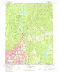
1980 Map of Paradise East
USGS Topo · Published 1980About this map
Magalia and Paradise anchor this detailed study of the Ridge, showing the transition from early mining roots to the established residential communities of the late twentieth century. Significant historical landmarks are documented, including the Historic Pioneer Church and the sites of former mining operations such as the Orofino Mine and Cory Mine. The landscape is defined by the steep canyons of Butte Creek and the West Fork Feather River, which dictated the layout of local roads like Skyway and Ponderosa Way. Water management systems are prominent, with the Magalia Reservoir and Paradise Lake providing essential infrastructure. Smaller settlements like Nimshew and the location of Irish Town illustrate the scattered development patterns typical of this gold-country region, while Lassen National Forest boundaries highlight the area's timber and natural resource heritage.
Find a feature on this map
70 named features on this map. Tap any name to fly to it.
Don’t see what you’re looking for? This feature index may not catch every label — zoom into the map to look around manually.
Map Details
Editions of this 1980 Paradise East Map
This is the sole edition of this map. No revisions or reprints were ever made.
Other maps of this area

1888 · Bidwell Bar
USGS Topo · 1:125,000

1891 · Bidwell Bar
USGS Topo · 1:125,000

1891 · Chico
USGS Topo · 1:125,000

1893 · Chico
USGS Topo · 1:125,000

1893 · Bidwell Bar
USGS Topo · 1:125,000

1895 · Bidwell Bar
USGS Topo · 1:125,000

1895 · Chico
USGS Topo · 1:125,000

1897 · Bidwell Bar
USGS Topo · 1:125,000

1912 · Clear Creek
USGS Topo · 1:31,680

1942 · Oroville
USGS Topo · 1:62,500