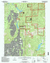
1994 Map of Paradise East
USGS Topo · Published 1998About this map
Paradise and Magalia form the heart of this landscape, where residential development transitions into the steep canyons and timberlands of the Lassen National Forest. The map captures the area just as the community of Paradise Pines was expanding northward along the Skyway. This territory is defined by its industrial history and water management, featuring several historic extraction sites such as the Madre de Oro Mine and Cory Mine. The complex water system, including the Magalia Reservoir and Paradise Lake, reflects the ongoing necessity of moving water through the Sierra Nevada foothills. Further east, the rugged terrain around the Feather River and Sawmill Peak remains largely undeveloped forest land, with landmarks like Beansoup Bar and Merchants Bar marking the remote riverbanks. This 1994 revision highlights the intersection of late-century suburban growth with the enduring legacy of California's gold-era mining and canyon infrastructure.
Find a feature on this map
70 named features on this map. Tap any name to fly to it.
Don’t see what you’re looking for? This feature index may not catch every label — zoom into the map to look around manually.
Map Details
Editions of this 1994 Paradise East Map
This is the sole edition of this map. No revisions or reprints were ever made.
Other maps of this area

1888 · Bidwell Bar
USGS Topo · 1:125,000

1891 · Bidwell Bar
USGS Topo · 1:125,000

1891 · Chico
USGS Topo · 1:125,000

1893 · Chico
USGS Topo · 1:125,000

1893 · Bidwell Bar
USGS Topo · 1:125,000

1895 · Bidwell Bar
USGS Topo · 1:125,000

1895 · Chico
USGS Topo · 1:125,000

1897 · Bidwell Bar
USGS Topo · 1:125,000

1912 · Clear Creek
USGS Topo · 1:31,680

1942 · Oroville
USGS Topo · 1:62,500