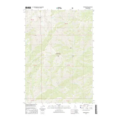
2017 Map of Paradise Peak
USGS Topo · Published 2017About this map
Sawtooth National Forest dominates this high-altitude landscape in Camas County, centered around the prominent summit of Paradise Peak. The topography is defined by a dense network of watercourses, including Big Smoky Cr and its various tributaries like N Fork Big Smoky Cr and Little Pinyon Cr. For those interested in the natural geography of the region, the map documents several glacial or alpine features such as Snowslide Lakes and Paradise Lake situated at high elevations near the peaks. A notable point of interest is Skiller Hot Springs, located along Skiller Cr south of Skillern Peak. The area is also marked by several high-elevation landmarks like Elk Point and Little Pinyon, alongside the specialized access provided by Headquarters Camp Cr.
Find a feature on this map
37 named features on this map. Tap any name to fly to it.
Don’t see what you’re looking for? This feature index may not catch every label — zoom into the map to look around manually.
Map Details
Editions of this 2017 Paradise Peak Map
This is the sole edition of this map. No revisions or reprints were ever made.
Other maps of this area

1900 · Sawtooth
USGS Topo · 1:125,000

1955 · Hailey
USGS Topo · 1:250,000

1959 · Hailey
USGS Topo · 1:250,000

1962 · Hailey
USGS Topo · 1:250,000

1964 · Frenchman Creek
USGS Topo · 1:24,000

1964 · Marshall Peak
USGS Topo · 1:24,000

1970 · Sydney Butte
USGS Topo · 1:24,000

1970 · Paradise Peak
USGS Topo · 1:24,000
1970 · Newman Peak
USGS Topo · 1:24,000

1970 · Dollarhide Mtn
USGS Topo · 1:24,000