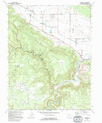
1994 Map of Paradox
USGS Topo · Published 1994About this map
Paradox and Bedrock anchor this rugged landscape of the Paradox Valley, where the drainage of West Paradox Creek and Paradox Creek defies typical topography by flowing across the valley floor. The map documents an intensive history of extraction, particularly along the slopes of Nyswonger Mesa and Ray Mesa. Researchers can trace the locations of numerous industrial sites, including the Morning Glory Mine, Cashin Mine, and Custom Mine, alongside various unnamed Quarries and Prospects. In the south, the Dolores River carves a deep path through the terrain, flanked by the high elevations of Skein Mesa and Davis Mesa. Transportation in this era relied on a mix of unimproved roads and specialized routes like the Pack Trail, while a remote Landing Strip and a Gaging Sta reflect the modern infrastructure supporting this isolated mining and ranching district.
Find a feature on this map
38 named features on this map. Tap any name to fly to it.
Don’t see what you’re looking for? This feature index may not catch every label — zoom into the map to look around manually.
Map Details
Editions of this 1994 Paradox Map
This is the sole edition of this map. No revisions or reprints were ever made.
Other maps of this area

1885 · La Sal
USGS Topo · 1:250,000

1916 · Paradox Valley
USGS Topo · 1:125,000

1922 · Paradox Valley
USGS Topo · 1:125,000

1948 · Roc Creek
USGS Topo · 1:24,000

1948 · Bull Canyon
USGS Topo · 1:24,000

1948 · Paradox
USGS Topo · 1:24,000

1949 · Bull Canyon
USGS Topo · 1:24,000

1949 · Davis Mesa
USGS Topo · 1:24,000

1949 · Paradox
USGS Topo · 1:24,000

1949 · Roc Creek
USGS Topo · 1:24,000