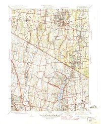
1945 Map of Park Ridge
USGS Topo · Published 1945About this map
The Saddle River and Pascack Brook valleys define the landscape of this 1945 survey, marking the borderlands of northern New Jersey and southern New York just before post-war suburbanization transformed the region. At this time, the area remained a mix of institutional grounds and small residential clusters. Significant facilities like Lederle Laboratories and the Edwin Gould Industrial School occupied large tracts of land, while the Fish Hatchery near Upper Saddle River points to the area's managed natural resources.
Find a feature on this map
72 named features on this map. Tap any name to fly to it.
Don’t see what you’re looking for? This feature index may not catch every label — zoom into the map to look around manually.
Map Details
Editions of this 1945 Park Ridge Map
2 editions found
Other maps of this area

1888 · Paterson
USGS Topo · 1:62,500

1891 · Ramapo
USGS Topo · 1:62,500

1891 · Harlem
USGS Topo · 1:62,500

1892 · Paterson
USGS Topo · 1:62,500

1892 · Tarrytown
USGS Topo · 1:62,500

1893 · Tarrytown
USGS Topo · 1:62,500

1893 · Ramapo
USGS Topo · 1:62,500

1897 · Harlem
USGS Topo · 1:62,500

1898 · Harlem
USGS Topo · 1:62,500

1898 · Paterson
USGS Topo · 1:62,500