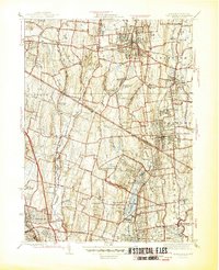
1945 Map of Park Ridge
USGS Topo · Published 1945About this map
The interstate border region between New York and New Jersey at the close of World War II is characterized by a dense network of suburban townships and industrial landmarks. Institutional landscapes are particularly prominent, including the St Agatha Home, the Edwin Gould Industrial School, and the sprawling Lederle Laboratories complex. These facilities, along with the Lakeside Home, highlight a period when large-scale social and scientific infrastructure was deeply integrated into the rolling geography of Orangetown and Ramapo.
Find a feature on this map
64 named features on this map. Tap any name to fly to it.
Don’t see what you’re looking for? This feature index may not catch every label — zoom into the map to look around manually.
Map Details
Editions of this 1945 Park Ridge Map
2 editions found
Other maps of this area

1888 · Paterson
USGS Topo · 1:62,500

1891 · Ramapo
USGS Topo · 1:62,500

1891 · Harlem
USGS Topo · 1:62,500

1892 · Paterson
USGS Topo · 1:62,500

1892 · Tarrytown
USGS Topo · 1:62,500

1893 · Tarrytown
USGS Topo · 1:62,500

1893 · Ramapo
USGS Topo · 1:62,500

1897 · Harlem
USGS Topo · 1:62,500

1898 · Harlem
USGS Topo · 1:62,500

1898 · Paterson
USGS Topo · 1:62,500