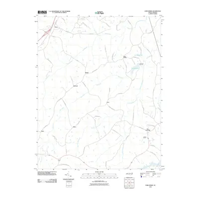
2010 Map of Park Spring
USGS Topo · Published 2010About this map
Moon Creek and its many branches, including the West Prong Moon Creek and East Prong Moon Creek, define the drainage patterns of this Caswell County landscape. The area is characterized by a network of rural settlements such as Bethel, Blackwell, Jones, and Park Spring, connected by winding roads that often bear family names, such as Ralph Daniels Rd and Pallie Watlington Rd. This 2010 survey illustrates a transition from traditional agricultural land use to a modern rural mix, featuring the Caswell Airpark near West Yanceyville and the water management infrastructure at Wildwood Lake Dam. Small communities like Swann and Quick appear alongside legacy sites like the Bethesda Church Cemetery Rd, while Old US Highway 29 skirts the northwestern corner, hinting at the evolving transportation corridors of the region.
Find a feature on this map
57 named features on this map. Tap any name to fly to it.
Don’t see what you’re looking for? This feature index may not catch every label — zoom into the map to look around manually.
Map Details
Editions of this 2010 Park Spring Map
This is the sole edition of this map. No revisions or reprints were ever made.
Other maps of this area

1923 · Danville
USGS Topo · 1:48,000

1924 · Draper
USGS Topo · 1:48,000

1925 · Danville
USGS Topo · 1:62,500

1926 · Draper
USGS Topo · 1:62,500

1944 · Draper
USGS Topo · 1:62,500

1953 · Greensboro
USGS Topo · 1:250,000

1954 · Greensboro
USGS Topo · 1:250,000

1962 · Greensboro
USGS Topo · 1:250,000

1965 · Danville
USGS Topo · 1:24,000
1965 · Brosville
USGS Topo · 1:24,000