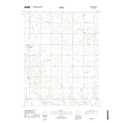
2018 Map of Parker
USGS Topo · Published 2018About this map
Parker serves as the primary municipal hub for this section of Linn County, anchored by a traditional grid including W Kimball St and E Main St. The surrounding landscape is defined by the drainage basins of Elm Creek and Sugar Creek, where the terrain transitions from upland plateaus into a network of small valleys. This 2018 survey reveals a rural structure where smaller crossroads like Cadmus and Goodrich persist alongside their respective burial grounds, such as Cadmus Cemetery and Goodrich Cemetery. A notable modern addition to the agricultural landscape is the G & S Space Port, located in the southeastern quadrant. Genealogists can trace family connections through numerous localized landmarks, including Walnut Grove Cemetery and the Parker Cemetery, which provide essential spatial context for the region's historical family plots and early prairie settlements.
Find a feature on this map
46 named features on this map. Tap any name to fly to it.
Don’t see what you’re looking for? This feature index may not catch every label — zoom into the map to look around manually.
Map Details
Editions of this 2018 Parker Map
This is the sole edition of this map. No revisions or reprints were ever made.
Other maps of this area

1885 · Garnett
USGS Topo · 1:125,000

1887 · Mound City
USGS Topo · 1:125,000

1893 · Mound City
USGS Topo · 1:125,000

1894 · Garnett
USGS Topo · 1:125,000

1947 · Lawrence
USGS Topo · 1:250,000

1950 · Lawrence
USGS Topo · 1:250,000

1956 · Lawrence
USGS Topo · 1:250,000

1958 · La Cygne
USGS Topo · 1:24,000
1958 · Fontana
USGS Topo · 1:24,000
1958 · Mound City
USGS Topo · 1:24,000