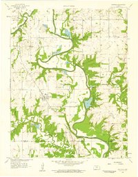
1958 Map of Fontana
USGS Topo · Published 1959About this map
Fontana sits as a central rail hub in the late 1950s, where the St Louis San Francisco railroad cuts through the valley floor. The town's grid is established west of the winding Marais Des Cygnes River, a watercourse characterized by heavy engineering including a system of levees and spoil banks. This landscape reflects a mix of agrarian life and early resource extraction, evidenced by an Oil Field in the northeast and various gravel pits and quarries scattered throughout the townships. Local civic life is anchored by rural institutions like the Trinity Sch and Hawkeye Sch, while the presence of Miami County State Park and Hunters Lake indicates a transition toward managed recreation and conservation. The map also delineates the jurisdictional boundary between Miami Co and Linn Co, tracing the movement of smaller tributaries like Hushpuckney Cr and Middle Creek.
Find a feature on this map
22 named features on this map. Tap any name to fly to it.
Don’t see what you’re looking for? This feature index may not catch every label — zoom into the map to look around manually.
Map Details
Editions of this 1958 Fontana Map
2 editions found
Other maps of this area

1887 · Olathe
USGS Topo · 1:125,000

1887 · Mound City
USGS Topo · 1:125,000

1893 · Mound City
USGS Topo · 1:125,000

1893 · Olathe
USGS Topo · 1:125,000

1947 · Lawrence
USGS Topo · 1:250,000

1950 · Lawrence
USGS Topo · 1:250,000

1956 · Paola East
USGS Topo · 1:24,000

1956 · Lawrence
USGS Topo · 1:250,000
1957 · Paola West
USGS Topo · 1:24,000
1957 · Louisburg
USGS Topo · 1:24,000