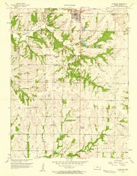
1957 Map of Louisburg
USGS Topo · Published 1958About this map
Louisburg stands as the primary hub in this late 1950s survey of eastern Kansas, situated along the Missouri Kansas Texas railroad line. The landscape is defined by the headwaters of several drainages, including Middle Creek, Rabbit Creek, and Sugar Creek, which carve through the terrain south of the town center. Local industry is clearly visible through numerous Oil Wells peppered across the countryside, particularly surrounding the Spring Valley Sch.
Find a feature on this map
24 named features on this map. Tap any name to fly to it.
Don’t see what you’re looking for? This feature index may not catch every label — zoom into the map to look around manually.
Map Details
Editions of this 1957 Louisburg Map
This is the sole edition of this map. No revisions or reprints were ever made.
Other maps of this area

1887 · Olathe
USGS Topo · 1:125,000

1887 · Mound City
USGS Topo · 1:125,000

1893 · Mound City
USGS Topo · 1:125,000

1893 · Olathe
USGS Topo · 1:125,000

1947 · Lawrence
USGS Topo · 1:250,000

1950 · Lawrence
USGS Topo · 1:250,000

1953 · Freeman
USGS Topo · 1:24,000

1953 · West Line
USGS Topo · 1:24,000

1956 · Bucyrus
USGS Topo · 1:24,000

1956 · Paola East
USGS Topo · 1:24,000