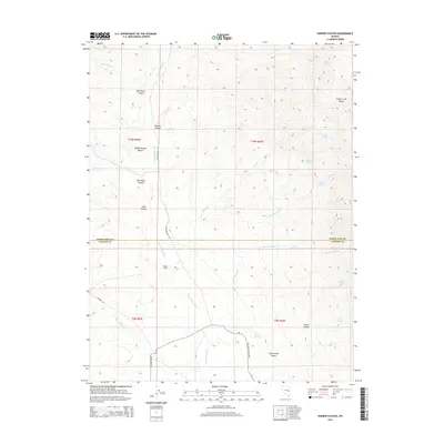
2014 Map of Parker Station
USGS Topo · Published 2014About this map
Parker Station serves as the focal point for this 2014 study of the high-desert landscape spanning the White Pine and Lincoln County line. The topography is dominated by the steep western slopes of the Schell Creek Range, where numerous canyons such as Milk Ranch Canyon, Willow Spring Canyon, and Blue Rock Canyon drain into the broad expanse of Cave Valley Wash. This area is characterized by its vital water sources, including Wildcat Spring, Sagehen Spring, and Sheep Spring, which have long been essential for ranching and travel in this arid environment. Roads like Patterson Pass Rd and Shingle Pass Rd trace the historical movement across the basins, while the presence of Cave Valley Ranch Rd indicates the continued agricultural utility of the valley floor.
Find a feature on this map
35 named features on this map. Tap any name to fly to it.
Don’t see what you’re looking for? This feature index may not catch every label — zoom into the map to look around manually.
Map Details
Editions of this 2014 Parker Station Map
This is the sole edition of this map. No revisions or reprints were ever made.
Other maps of this area

1956 · Lund
USGS Topo · 1:250,000

1960 · Lund
USGS Topo · 1:250,000

1969 · Shingle Pass
USGS Topo · 1:24,000

1969 · Parker Station
USGS Topo · 1:24,000

1969 · Shingle Pass SE
USGS Topo · 1:24,000

1969 · Haggerty Spring
USGS Topo · 1:24,000

1973 · Cattle Camp Spring
USGS Topo · 1:24,000
1977 · Bullwhack Summit
USGS Topo · 1:24,000
1977 · Brown Knoll
USGS Topo · 1:24,000
1978 · Mt. Grafton
USGS Topo · 1:24,000