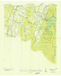
1935 Map of Parksville
USGS Topo · Published 1935About this map
Ocoee Power Plant Dam No 1 anchors this 1935 survey, a period when the Tennessee Valley Authority was actively transforming the region's infrastructure. The map details the impoundment of Lake Ocoee, showing the submerged riverbed of the Ocoee River and the emerging recreational landscape at Shady Beach and Camp Ocoee. Industrial development is evident through the extensive Tennessee Electric Power Company Transmission Line network and the Nashville and Louisville RR corridor cutting through the western valley.
Find a feature on this map
57 named features on this map. Tap any name to fly to it.
Don’t see what you’re looking for? This feature index may not catch every label — zoom into the map to look around manually.
Map Details
Editions of this 1935 Parksville Map
This is the sole edition of this map. No revisions or reprints were ever made.
Other maps of this area

1886 · Dalton
USGS Topo · 1:125,000

1886 · Cleveland
USGS Topo · 1:125,000

1892 · Cleveland
USGS Topo · 1:125,000

1892 · Dalton
USGS Topo · 1:125,000

1895 · Cleveland
USGS Topo · 1:125,000

1897 · Dalton
USGS Topo · 1:125,000

1901 · Cleveland
USGS Topo · 1:125,000

1911 · Cohutta Mtn
USGS Topo · 1:62,500

1913 · Cohutta Mtn.
USGS Topo · 1:62,500

1935 · East Cleveland
USGS Topo · 1:24,000