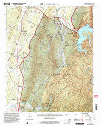
2003 Map of Parksville
USGS Topo · Published 2004About this map
The Ocoee River and its dramatic impoundment dominate this landscape at the western edge of the Cherokee National Forest. This 2003 revision, based on imagery from the turn of the century, captures the transition from the river valley's settled bottomlands to the steep rises of Sand Mountain and the Beans Mountain ridge. The settlement pattern reflects the area's geography, with clusters of development at Ocoee and Parksville near the water, while southern agrarian communities like Oldfort and Conasauga sit along the lower elevation transport corridors. This map is particularly detailed regarding recreation and conservation boundaries, documenting the extensive network of forest service roads and established sites like the Camp Ocoee Organization Camp along the shoreline of Lake Ocoee.
Find a feature on this map
4 named features on this map. Tap any name to fly to it.
Don’t see what you’re looking for? This feature index may not catch every label — zoom into the map to look around manually.
Map Details
Editions of this 2003 Parksville Map
This is the sole edition of this map. No revisions or reprints were ever made.
Other maps of this area

1886 · Dalton
USGS Topo · 1:125,000

1886 · Cleveland
USGS Topo · 1:125,000

1892 · Cleveland
USGS Topo · 1:125,000

1892 · Dalton
USGS Topo · 1:125,000

1895 · Cleveland
USGS Topo · 1:125,000

1897 · Dalton
USGS Topo · 1:125,000

1901 · Cleveland
USGS Topo · 1:125,000

1911 · Cohutta Mtn
USGS Topo · 1:62,500

1913 · Cohutta Mtn.
USGS Topo · 1:62,500

1935 · East Cleveland
USGS Topo · 1:24,000