1964 Map of Pasco
USGS Topo · Published 1966About this map
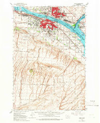
Pasco and Kennewick serve as the industrial and transit hubs of the Tri-Cities region in the mid-1960s, defined by the convergence of the Columbia River and Snake River. The landscape is a study in mid-century development, where irrigation projects like the Highland Feeder Canal and numerous siphons have transformed the arid terrain adjacent to the Horse Heaven Hills. This era shows the vital river-and-rail infrastructure in its prime, with the Union Pacific and Spokane Portland and Seattle railroads connecting the Port of Pasco to the wider world.
Find a feature on this map
56 named features on this map. Tap any name to fly to it.
Don’t see what you’re looking for? This feature index may not catch every label — zoom into the map to look around manually.
Map Details
Editions of this 1964 Pasco Map
This is the sole edition of this map. No revisions or reprints were ever made.
Other maps of this area

1908 · Umatilla
USGS Topo · 1:125,000

1915 · Wallulah
USGS Topo · 1:96,000

1917 · Pasco
USGS Topo · 1:125,000

1918 · Wallula
USGS Topo · 1:125,000

1935 · Pendleton
USGS Topo · 1:125,000

1951 · Richland
USGS Topo · 1:62,500

1953 · Pendleton
USGS Topo · 1:250,000

1953 · Walla Walla
USGS Topo · 1:250,000

1956 · Pendleton
USGS Topo · 1:250,000

1958 · Walla Walla
USGS Topo · 1:250,000