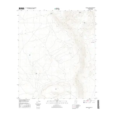
2016 Map of Paso Del Norte
USGS Topo · Published 2016About this map
Paso del Norte stands at the northwestern corner of this Brewster County landscape, marking a historical passage point through the arid West Texas terrain. The map is defined by the significant vertical relief of the Cochran Mountains in the northeast, where Bear Canyon cuts deeply into the uplift. To the south, the isolated mass of Black Mtn rises above the surrounding basin, creating a prominent landmark for those navigating this portion of the Trans-Pecos. Drainage patterns are clearly etched into the desert floor, with Chalk Draw and the broad Chalk Valley serving as the primary geographical features that channel seasonal water through this sparsely populated cattle country. This 2016 survey provides a precise modern record of the roads and physical landmarks that have long dictated movement through these high-altitude desert basins.
Find a feature on this map
6 named features on this map. Tap any name to fly to it.
Don’t see what you’re looking for? This feature index may not catch every label — zoom into the map to look around manually.
Map Details
Editions of this 2016 Paso Del Norte Map
This is the sole edition of this map. No revisions or reprints were ever made.
Other maps of this area

1895 · Alpine
USGS Topo · 1:125,000

1917 · Santiago Peak
USGS Topo · 1:62,500

1917 · Buck Hill
USGS Topo · 1:62,500

1918 · Bone Spring
USGS Topo · 1:125,000

1918 · Buck Hill
USGS Topo · 1:62,500

1918 · Santiago Peak
USGS Topo · 1:62,500

1920 · Monument Spring
USGS Topo · 1:62,500

1921 · Monument Spring
USGS Topo · 1:62,500

1925 · Buck Hill
USGS Topo · 1:62,500
1938 · Santiago Peak
USGS Topo · 1:62,500