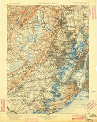
1900 Map of Passaic
USGS Topo · Published 1900About this map
The Narrows serves as the gateway to this turn-of-the-century landscape where New Jersey’s industrial corridors meet the New York harbor. Maritime activity is anchored by Passaic Light and Robins Reef Light, while the defensive presence of Fort Wadsworth and Fort Hamilton guards the entry to Upper Bay. Inland, the complex interplay of water and transport is evident in the winding Morris Canal and the extensive rail network, including the Hibernia Mine R.R. and the Pennsylvania R.R..
Find a feature on this map
362 named features on this map. Tap any name to fly to it.
Don’t see what you’re looking for? This feature index may not catch every label — zoom into the map to look around manually.
Map Details
Editions of this 1900 Passaic Map
This is the sole edition of this map. No revisions or reprints were ever made.
Other maps of this area

1888 · Franklin
USGS Topo · 1:62,500

1888 · Plainfield
USGS Topo · 1:62,500

1888 · Morristown
USGS Topo · 1:62,500

1888 · New Brunswick
USGS Topo · 1:62,500

1888 · Princeton
USGS Topo · 1:62,500

1888 · Lake Hopatcong
USGS Topo · 1:62,500

1888 · Paterson
USGS Topo · 1:62,500

1888 · Sandy Hook
USGS Topo · 1:62,500
1889 · Brooklyn
USGS Topo · 1:62,500

1891 · Somerville
USGS Topo · 1:62,500