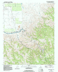
1991 Map of Pastoria Creek
USGS Topo · Published 1992About this map
The Tejon Oil Field and the complex infrastructure of the California Aqueduct dominate this landscape where the Central Valley meets the northern Tehachapi Mountains. This map captures the massive engineering effort required to move water through the region, featuring the AD Edmonston Pumping Plant and a series of underground passages including Tehachapi Tunnel No 1. The transition from industrial water management and petroleum extraction to traditional ranching is evident in the holdings of the Tejon Ranch, with various outposts like Ranch-B and Ranch-D scattered across the higher elevations. Natural drainage systems like Pastoria Creek and Tunis Creek cut through the steep terrain of Alamos Y Agua Caliente, providing a sharp contrast to the geometric lines of Laval Road and the irrigation canals found on the valley floor near Laval.
Find a feature on this map
41 named features on this map. Tap any name to fly to it.
Don’t see what you’re looking for? This feature index may not catch every label — zoom into the map to look around manually.
Map Details
Editions of this 1991 Pastoria Creek Map
This is the sole edition of this map. No revisions or reprints were ever made.
Other maps of this area

1903 · Tejon
USGS Topo · 1:125,000

1914 · Caliente
USGS Topo · 1:125,000

1931 · West of Tejon Hills
USGS Topo · 1:31,680

1931 · Tejon Hills
USGS Topo · 1:31,680

1933 · Tejon Hills
USGS Topo · 1:31,680
1934 · West of Tejon Hills
USGS Topo · 1:31,680

1942 · Tecuya Creek
USGS Topo · 1:24,000

1942 · Frazier Mountain
USGS Topo · 1:24,000

1943 · Cummings Mountain
USGS Topo · 1:62,500

1943 · Neenach
USGS Topo · 1:62,500