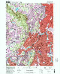
1995 Map of Paterson
USGS Topo · Published 1999About this map
The Passaic River defines the urban and industrial heart of this landscape as it winds through Paterson and Clifton, showing the dense development of the late twentieth century. This map documents a complex metropolitan area where the rugged heights of the Watchung Mountains and High Mtn meet the valley floors. In the more suburban reaches of Franklin Lakes and Wayne, larger tracts of land like the High Mountain Wilderness Township Park and Point View Reservoir remain as natural breaks in the sprawl.
Find a feature on this map
96 named features on this map. Tap any name to fly to it.
Don’t see what you’re looking for? This feature index may not catch every label — zoom into the map to look around manually.
Map Details
Editions of this 1995 Paterson Map
This is the sole edition of this map. No revisions or reprints were ever made.
Other maps of this area

1888 · Morristown
USGS Topo · 1:62,500

1888 · Paterson
USGS Topo · 1:62,500

1891 · Greenwood Lake
USGS Topo · 1:62,500

1891 · Ramapo
USGS Topo · 1:62,500

1892 · Paterson
USGS Topo · 1:62,500

1893 · Greenwood Lake
USGS Topo · 1:62,500

1893 · Ramapo
USGS Topo · 1:62,500

1894 · Morristown
USGS Topo · 1:62,500

1898 · Morristown
USGS Topo · 1:62,500

1898 · Paterson
USGS Topo · 1:62,500