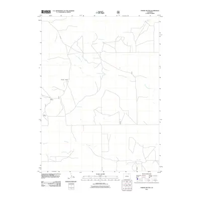
2011 Map of Pawnee Buttes
USGS Topo · Published 2011About this map
Pawnee Buttes dominates this landscape of the High Plains, standing as a prominent geological landmark within the northeastern Colorado shortgrass prairie. The topography is defined by the seasonal drainage of North Pawnee Creek and Igo Creek, which carve through the arid terrain. For those tracing the human and livestock history of the region, the placement of isolated water sources like Elizabeth Spring, De Moss Spring, and The Wolf Spring is significant. These springs, alongside the Durbin Windmill and Buttes Windmill, reflect the essential infrastructure required for ranching and survival in this environment. The presence of the Pawnee Butte Trail Head indicates the area's continued importance for recreation and access to the notable butte formations.
Find a feature on this map
11 named features on this map. Tap any name to fly to it.
Don’t see what you’re looking for? This feature index may not catch every label — zoom into the map to look around manually.
Map Details
Editions of this 2011 Pawnee Buttes Map
This is the sole edition of this map. No revisions or reprints were ever made.
Other maps of this area

1954 · Sterling
USGS Topo · 1:250,000

1954 · Greeley
USGS Topo · 1:250,000

1957 · Greeley
USGS Topo · 1:250,000

1958 · Greeley
USGS Topo · 1:250,000

1958 · Sterling
USGS Topo · 1:250,000

1961 · Greeley
USGS Topo · 1:250,000

1964 · Greeley
USGS Topo · 1:250,000

1965 · Greeley
USGS Topo · 1:250,000
1972 · Keota
USGS Topo · 1:24,000
1972 · Grover SE
USGS Topo · 1:24,000