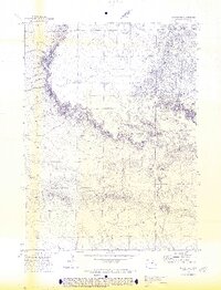
1972 Map of Grover SE
USGS Topo · Published 1974About this map
Sidney sits at the northern edge of this high plains landscape, situated near the head of Sidney Draw. The area is defined by the sharp, etched drainage systems of the Pawnee National Grassland vicinity, where seasonal watercourses like Wild Horse Creek have carved deep into the terrain. This 1970s topographic record shows a landscape dedicated largely to resource extraction and utility, evidenced by the numerous scattered Well and Wells sites throughout the quadrangle. A solitary Radio Tower provides a modern landmark on the higher ground between the draws, while industrial activity is further marked by a Mill and a specific Drill Hole location in the western section. The map captures the region's sparse settlement pattern, focusing instead on the complex network of ephemeral creeks and the infrastructure required for plains ranching or energy exploration.
Find a feature on this map
11 named features on this map. Tap any name to fly to it.
Don’t see what you’re looking for? This feature index may not catch every label — zoom into the map to look around manually.
Map Details
Editions of this 1972 Grover SE Map
3 editions found
Other maps of this area

1954 · Sterling
USGS Topo · 1:250,000

1954 · Greeley
USGS Topo · 1:250,000

1957 · Greeley
USGS Topo · 1:250,000

1958 · Greeley
USGS Topo · 1:250,000

1958 · Sterling
USGS Topo · 1:250,000

1961 · Greeley
USGS Topo · 1:250,000

1964 · Greeley
USGS Topo · 1:250,000

1965 · Greeley
USGS Topo · 1:250,000
1972 · Grover North
USGS Topo · 1:24,000

1972 · Keota NW
USGS Topo · 1:24,000