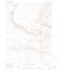
1972 Map of Grover SE
USGS Topo · Published 1975About this map
Hoffman sits as a quiet focal point within this 1972 survey of northeastern Colorado, a landscape defined by the drainage patterns of the Great Plains. The map captures a moment when the land was primarily organized for ranching and resource extraction, evidenced by the numerous Wells and an isolated Mill located near the center of the sheet. The terrain is marked by seasonal watercourses like Sidney Draw and Wild Horse Creek, which carve through the plains toward North Pawnee Creek. These natural features, along with prominent landmarks like the Cone and a central Radio Tower, served as essential navigational markers in an area of high visibility and sparse settlement. For researchers, the inclusion of several Drill Holes points to the mid-century exploration of the region's subsurface potential, while fine red dashed lines indicate the established fence lines that partitioned this wide-open Weld County terrain.
Find a feature on this map
15 named features on this map. Tap any name to fly to it.
Don’t see what you’re looking for? This feature index may not catch every label — zoom into the map to look around manually.
Map Details
Editions of this 1972 Grover SE Map
3 editions found
Other maps of this area

1954 · Sterling
USGS Topo · 1:250,000

1954 · Greeley
USGS Topo · 1:250,000

1957 · Greeley
USGS Topo · 1:250,000

1958 · Greeley
USGS Topo · 1:250,000

1958 · Sterling
USGS Topo · 1:250,000

1961 · Greeley
USGS Topo · 1:250,000

1964 · Greeley
USGS Topo · 1:250,000

1965 · Greeley
USGS Topo · 1:250,000
1972 · Grover North
USGS Topo · 1:24,000

1972 · Keota NW
USGS Topo · 1:24,000